Place Polygon Creation Methodology
Generation of accurate, independent, and responsibly produced polygons to capture visitation and ad exposure within a venue is essential for the Motionworks Population Intelligence Platform.
Motionworks Place Creation
After years of experience in measuring place-based audiences, Motionworks invested significant resources in the curation of standardized best practices for the generation of place polygons across the landscape of place-types. Motionworks place polygons are created by expert auditors and are not generated through automated means which can often lead to inconsistent and inaccurate results.
In addition to curating the place polygons, our auditors capture metadata about each place, including the hours of operation the location of entrances and exits, number of floors, and associated footprints.
Motionworks has curated a standard ruleset to estimate visitation in additional complex scenarios like multi-storied buildings with multiple places inside, and situations where residences are located within the same building as businesses. Incremental analysis utilizing metrics such as the area sq. footage and the identification of residents are incorporated into the data modeling to generate appropriate visitation metrics. These situations are audited and analyzed on a case-by-case basis.
Primary Metadata
-
Hours of Operation
- From reputable primary or secondary sources. Possibly estimated from place type if no source is available. An example of this type of estimation would be using maximum last call laws in restaurants to determine when it might close. Deeper audits and investigations are always possible on a case by case basis.
-
Exits / Entrances
- Motionworks collect's the number of entrances and/or exits, but does not differentiate and doest not mark specific locations of them. This number is derived from reputable primary or secondary sources. In cases where source data is not available, it is possible to estimate the number based on the type of place being audited.
-
Number of Floors
- The collection of the number of floors is very similar to the collection of exits/entrances. Larger buildings can be verified from reputable primary or secondary sources.
Special metadata
-
Transit Stations
- Number of concourses and platforms, both open and underground. Mainly from Transit Agencies, and other transit data sources
-
Airports
- Number of concourses, gates. Collected from Airport Authorities.
-
Shopping Malls
- Gross leaseable area – Retail SQ Footage available. Collected from primary sources or third party property management data providers.
-
Parent / Child relationships
- If a place can’t be isolated, it’s assigned a parent place. Circulation for the child is then adjusted based on the average circulation of every location of the same place type in the market and the circulation of the parent venue
Place Type Creation Examples
Below are examples of venues that Motionworks has analyzed and details on the reasoning behind the approach to polygon creation.
| Place Type | Creation Process |
|---|---|
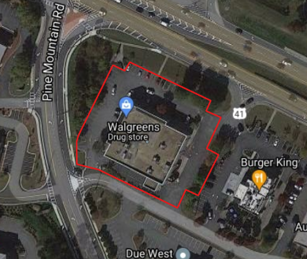
| Standalone Retail
| The simplest venue type to capture are stand-alone retail locations with individual parking lots. The building itself, as well as the surrounding parking lot, are included in the polygon. |
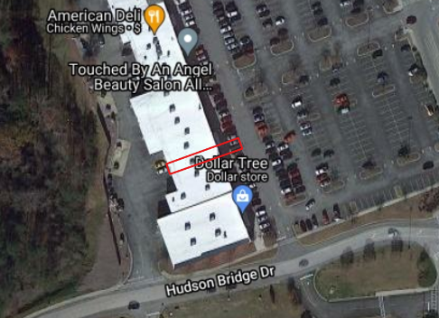
| Minor Retail
| It is more complicated when a venue is nested within a larger facility. In this situation, the Dollar Tree is a “child” nested within a strip mall that is referred to as the “parent” venue. In these cases, the venue itself is captured in the polygon in addition to the parking spots immediately in front of the venue. The rest of the parking lot is excluded as there is no way to ascertain which vehicles are occupied by visitors to the store, however, it can be reasonably assumed that the parking spots directly in front of the venue are occupied by individuals visiting the store. |
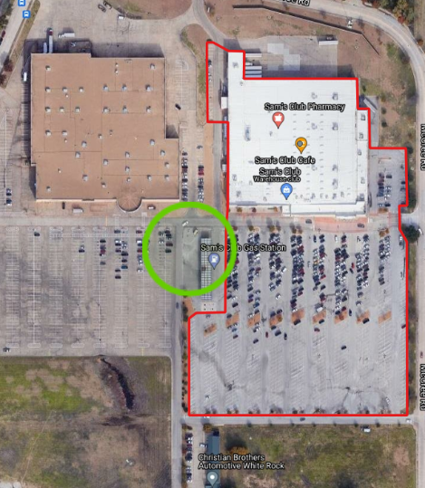
| Major Retail
| In this example, the parking lot that is associated with this retailer has distinct borders that differentiate it from the venue next door. The retail footprint and the entire associated parking lot are included within the polygon. What is unique to highlight in this scenario is the area circles in green. It is a gas-station embedded in the parking lot. In situations like this, the gas station, and the pass-through areas around it, are excluded from the polygon. |
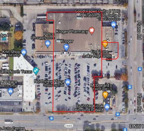
| Grocery Store
| In this scenario, a large grocery store is connected to another retailer and a restaurant. The grocery store occupies the majority of the footprint of the venue. The footprint of the store, as well as the parking lot in front of the store, is included in the polygon. The footprint of the other retailers and their corresponding parking places are excluded. |
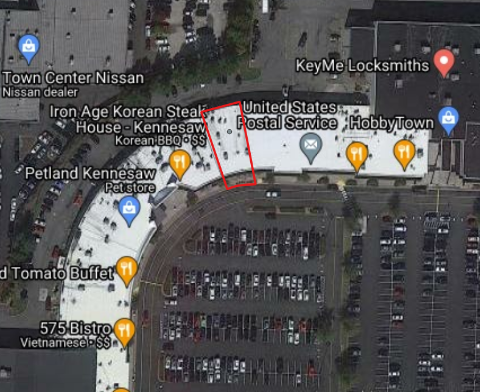
| Shopping Center
| In this situation, a smaller child venue is located within a large parent venue. What is unique about this venue is that there is a large “roadway” inside the parking lot that separates the venue from the parking spaces. In scenarios such as this, the polygon is curated to only include the retailer’s footprint and any pedestrian area in front of the venue. |
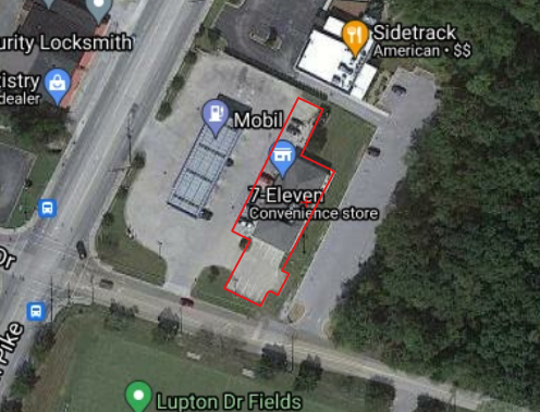
| Convenience Store
| The advertising at this location is only located within the convenience store itself. It cannot be seen from the gas pumps. As a result, the convenience store itself, as well as the surrounding parking spots, are included in the polygon, but the gas pumps themselves, and the pass-through lanes, are excluded. |
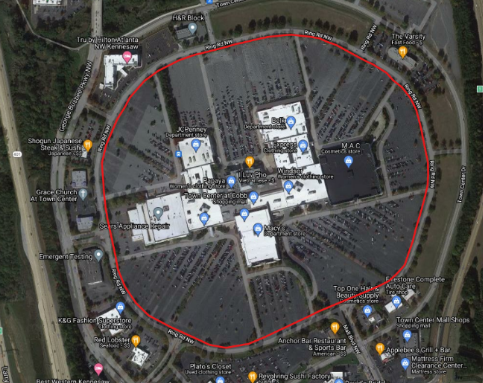
| Traditional Mall
| This mall includes a large, centralized building with satellite buildings located on the outside of a dedicated, circular, roadway. In order to measure inventory within the large mall venue alone, the mall and the parking lots located on the inside of the roadway are included in the polygon. The roadway itself is excluded as it may contain individuals who are only visiting the satellite buildings. |
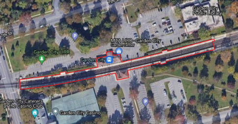
| Above Ground Transit Station
| In the situation of an above-ground transit station with ad inventory located on the platform itself, only the platform and the structures attached to it are included in the polygon. The parking lots are excluded due to the large number of pick-up and drop-off vehicles that do not get exposure to the OOH advertising on the platform. Additionally, Motionworks has found that many rail station parking lots are shared with bus stops. |
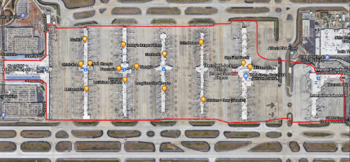
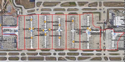
| Airports and Terminals
| Motionworks generates polygons around the entire airport and isolates each individual terminal as well as general public areas. In the case of large, public airports, the parking lot is excluded from the polygon due to the large number of pick-up and drop-off vehicles that do not enter the actual venue. In the case of small, private airports, Motionworks may include specific areas of the tarmac and private parking areas. |
Effects on Measurement
Data collected about a place could effect the overall measurement of that place in the Motionworks Population Intelligence Platform.
Metadata with direct effects
This is the information about a place that when created or changed has an immediate impact on the measurement of that place.
- Place Shape
- This represents the physical area that Motionworks uses to collect mobile location data. Changes to this, will result in a different area of collection.
- Place Type
- This categorizes the place and has a direct effect on how dwell time is measured for a specific place.
- Parent Place
- If the place record is part of a parent / child relationship, the details of the parent place, and the measurement of that parent place, have a direct effect on child places.
- Focused Status
- Each place is either focused or unfocused which effects how Motionworks uses the observed data about a place in our measurement process.
Metadata with secondary effects
This is the information about a place that when created or change could eventually impact the measurement of that place. This impact occurs because of the way this data about is place is used in the Motionworks measurement process.
Much of this metadata is used in determining how a place fits into its "Peer Group" of places, which is part of the Placecast measurement process. A change to how a place fits into its Peer Group, would impact measurement of that specifc place, and could also have a broader effect on all places in that Peer Group.
- Latitude and Longitude
- This information is derived from the Place Shape, and is used to look up the geography data (for example, census block group, timezone) for that place. If there was a change in shape that changed this lookup and derived geography data, it could impact inputs to the measurement process that use that derived geography data.
- Similarly, a change to the market that the place is within (based on the latitude / longitude) could effect the "Peer Group" of places for the specific place, which would effect how the specific place behaves in relation to its Peer Group, which is a component in how a place is measured.
- Audit Status
- This is a Motionworks maintained piece of data that tracks the status of a place as Motionworks staff review and edit it. A change here primarily effects how a place moves through the measurement process, and how it fits into its Peer Group of places.
- Hours of Operation
- This data used to help validate the measurement that is being seen from a place. More information can be found here
Data from Outside Sources
Some data that is used to help categorize specific places comes from sources external to Motionworks that is used directly by Motionworks. Any changes to this data will be incorporated into the Motionworks process and could effect a specific place directly, or indirectly by changing the understanding of the Peer Group of the specific place.
- DMA
- From Claritas
- Urbanicity
- From Claritas
- Block Group
- From the US Census Bureau
Updated 3 days ago